AASTHA
Yamuna's Delhi
Advocacy through alternative urban visions for the floodplains of Yamuna river in Delhi, Bottom up mapping and Public events to make a case for preservation of farming and associated livelihoods
Role: Bottom-Up Mapping, Visualisation, Identity Design, Exhibition Design
Timeline: 2021- 22 l 8 Weeks
5 BIGHA ZAMEEN
Art as Social Practice supported by Khoj Studios
'5 Bigha Zameen' aims to rethink our collective imaginations of the city and question whose rights are protected in our cities, and whose eroded.d.
5 bigha or 1 acre is the minimum unit of land for subsistence of the farmers of Yamuna Khadar - the eastern floodplains of Yamuna in the city. While this unit of area has been long used as a guiding principle in urban planning and utopian concepts, it is more importantly the basic element linked to the lives, livelihoods and histories of farmers who are today facing the imminent threat of erasure from the heart of the capital city.
The year long engagement as part of the "Peripheries and Crossovers" with suport of Khoj Studios project focuses on rights based advocacy with the women of Yamuna Khadar on one hand and creating public awareness on their invisible role in the city, on the other.

Methodology
Field Study
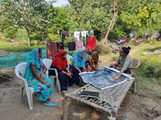
Collaborative Scrapbook
a tool for documentation, discourse and participatory urban planning


Mapping
Visualising data gathered on ground to develop a case for farmers of Yamuna


CHALO YAMUNA
Walks led by Farmers
'Chalo Yamuna' walks led by the farmers highlight the significance of the farming communities who are currently at a high risk of eviction.
A series of 4 walks over two weekends invited people from all walks of life to witness the lives that for decades now have been producing food and plants for rest of the city. The curated event talked about the various ebbs and flows of the communities from socio-economic, historic, cultural and political lenses.


Travelling Bedsheet
Textile Archive traveling from house to house as the farmers add their home and farms to it. Led by the women farmers in the area, this traveling map was important to create as a response to the absence of the community from any map drawn by the planning authorities.


Exhibition
The exhibition displayed all the work produced so far in collaboration with the women farmers to raise the question - whose city is it? What kind of a riverfront can we collectively reimagine?


Saturday Walks
A total of 4 walks were conducted over 2 weekends
The Saturday Walks in the Yamuna Khadar area were led by Naresh, a teacher and a community mobilizer. He took us through the 'farm to table' journey of the seasonal vegetables grown in the area which is intimately linked to the food production network in Delhi.
Sunday Walks
A total of 4 walks were conducted over 2 weekends
The Sunday walks in the area behind Akshardham were led by Pooja Verma, a farmer and a community leader. She took us through the women-led farms that grow ornamental plants for nurseries not just across Delhi but also other Indian cities.
Saturday Walks
Sunday Walks
BOTTOM UP MAPPING
Quantitative Research Report
A community driven mapping of the extent of farmlands along the Yamuna and the riverine livelihoods in Delhi. The objective of the report is to, first, document a quantitative assessment of habitat on the river floodplains, asking such questions as what constitutes a basti in this context and how many such bastis exist throughout the length and breadth. Next, it connects habitat with livelihood to present a comprehensive database of work and occupation in this region. In this process, land use patterns as reflected by on-ground practises are juxtaposed against those mandated by key planning and policy documents such as the Master Plan for Delhi 2021 and judicial orders.

Maps
This Basti wise study looks at history & economics also drawing finding about the interconnectedness of the city through farming
Timeline Age of Bastis

Animal Husbandry in Zone 0

Crops in Zone 0 what grows here?


